|
|
|
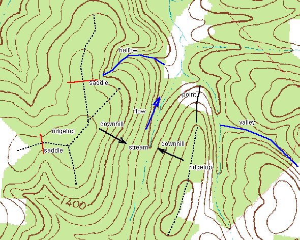 There are a number of features useful to hunters visible
on this drawing. I have marked a couple of the ridgetops for your
identification (dotted lines). Note that the contours in a valley
or hollow always point uphill. Note the two saddles I have
marked. Animals like to use these features to cross ridgetops more
easily and they also provide cover. Animals will more readily use
saddles to cross a ridgetop although if pressured they will use
ANY means of escape. Note the large open vally in the center near
the top. This is a place where several valleys(hollows) come
together. Note that several streams flow into the major stream in
that area. Note the steep ridge at the top center of the map.
Also a steep ridge lies in the center to the right where I have the
ridgetop marked. Game will travel along steep hillsides more
readily than up or down them. Animals, especially in the fall and
winter months do not expend more energy than is necessary. Also,
in the valley where several streams flow together you could
expect to find more dense vegetation due to the availabilty of
good topsoil being washed down from above and being near a good
source of water.
There are a number of features useful to hunters visible
on this drawing. I have marked a couple of the ridgetops for your
identification (dotted lines). Note that the contours in a valley
or hollow always point uphill. Note the two saddles I have
marked. Animals like to use these features to cross ridgetops more
easily and they also provide cover. Animals will more readily use
saddles to cross a ridgetop although if pressured they will use
ANY means of escape. Note the large open vally in the center near
the top. This is a place where several valleys(hollows) come
together. Note that several streams flow into the major stream in
that area. Note the steep ridge at the top center of the map.
Also a steep ridge lies in the center to the right where I have the
ridgetop marked. Game will travel along steep hillsides more
readily than up or down them. Animals, especially in the fall and
winter months do not expend more energy than is necessary. Also,
in the valley where several streams flow together you could
expect to find more dense vegetation due to the availabilty of
good topsoil being washed down from above and being near a good
source of water.
 Note the saddle in the foreground of this relief map.
It would be a good place to wait for deer coming in from the
field on the right in the morning or waiting for them in the
evening to travel toward the field. Place your stand nearer the
stream, because of the close proximity of the field, the deer are
likely to lay up for a while before nearing the field and are
likely to cross the stream after daylight in the morning. Find
the hollow in the center of the relief map. The one pointing
straight to the left. To my knowledge more deer have been taken
in that area than in any other one area in this location. Deer
cross that hollow near the top or go into the hollow and cross
the ridge at the saddle formed there. Deer also come down the
points of any of those ridges and cross the stream to the other
ridges. Turkeys also like to roost on any of those points. It
gives them easy access to water and gravel in the morning so that
they may digest their food.
Note the saddle in the foreground of this relief map.
It would be a good place to wait for deer coming in from the
field on the right in the morning or waiting for them in the
evening to travel toward the field. Place your stand nearer the
stream, because of the close proximity of the field, the deer are
likely to lay up for a while before nearing the field and are
likely to cross the stream after daylight in the morning. Find
the hollow in the center of the relief map. The one pointing
straight to the left. To my knowledge more deer have been taken
in that area than in any other one area in this location. Deer
cross that hollow near the top or go into the hollow and cross
the ridge at the saddle formed there. Deer also come down the
points of any of those ridges and cross the stream to the other
ridges. Turkeys also like to roost on any of those points. It
gives them easy access to water and gravel in the morning so that
they may digest their food.
I hope that you have found this explanation of topo maps helpful. By all means if there are any questions you might have or if you think there needs to be more explanations here write me an e-mail and I WILL try to help you. Topo maps can be a great aid to hunting. they can make your job of scouting MUCH easier and efficient. In these days many people don't have the time that would be necessary to scout an area properly ahead of hunting season. Topo maps can help to point you in the right direction. Remember that food plays THE major role in determining deer movements. So terrain may not always be the major factor in deer movement.ie If there was no feed in the field to the right then there would be few deer traveling that saddle in the morning and evening. I hope this short course in map reading has helped you to be more successful in finding your quarry.
LINKS: