|
|
|
a service of Dave's Hunting Page
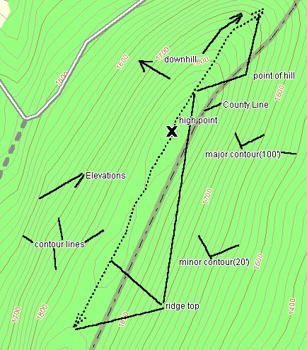 The light brown lines are
contour lines which show changes in elevation. The difference in
elevation between these lines on a USGS 7.5 minute quad is 20'.
The darker brown lines are major contours and depict 100'
elevations and are labelled at regular intervals on the mapThe
dotted line I have drawn here shows the top of the ridge. At the
end of the ridge the contours bend and form a feature known as a
point. A point is an important feature in hunting because it
allows the hunter or game to look down in three directions. The
place that I have marked with an "X"
is known as a high point and is usually labelled with an "X"
and an elevation on USGS topo maps. One can tell how steep a
slope is by noticing the spacing between the contours. the closer
the contours are together the steeper the slope. Notice this on
the relief map I have shown below. It also depicts the same area
as this map. Notice how the spacing in the contour lines widens
at the top where it levels out. Also note the small depression in
the foreground on the ridgetop. This feature is known as a
saddle. A saddle is of paramount importance to hunters. It is a
place that game will choose to cross the top of this ridge as it
affords ease and cover to the game. Take note of the bends in the
contour lines they delineate valleys and peaks or points. Green
areas usually depict forested areas. However in developing areas
this may not always hold true. The white areas are fields or open
areas. now on to page 2 for more topographic features.
The light brown lines are
contour lines which show changes in elevation. The difference in
elevation between these lines on a USGS 7.5 minute quad is 20'.
The darker brown lines are major contours and depict 100'
elevations and are labelled at regular intervals on the mapThe
dotted line I have drawn here shows the top of the ridge. At the
end of the ridge the contours bend and form a feature known as a
point. A point is an important feature in hunting because it
allows the hunter or game to look down in three directions. The
place that I have marked with an "X"
is known as a high point and is usually labelled with an "X"
and an elevation on USGS topo maps. One can tell how steep a
slope is by noticing the spacing between the contours. the closer
the contours are together the steeper the slope. Notice this on
the relief map I have shown below. It also depicts the same area
as this map. Notice how the spacing in the contour lines widens
at the top where it levels out. Also note the small depression in
the foreground on the ridgetop. This feature is known as a
saddle. A saddle is of paramount importance to hunters. It is a
place that game will choose to cross the top of this ridge as it
affords ease and cover to the game. Take note of the bends in the
contour lines they delineate valleys and peaks or points. Green
areas usually depict forested areas. However in developing areas
this may not always hold true. The white areas are fields or open
areas. now on to page 2 for more topographic features.

This is a cross section of a relief map which shows the elevations to aid in visualizing the contours.
Links: